Purpose
- Explores and develops market-based solutions.
Summary
In November 2022, the Monteverde Conservation League received a grant from the Alex C. Walker Foundation for the amount of $20,000. The primary goal for this project was to use GIS techniques to map areas adjacent to the Children’s Eternal Rainforest (Bosque Eterno de los Niños, “BEN”) in order to identify the best places to concentrate land purchases in the future. With GIS technology, we can identify areas that have highest ecosystem services values, biodiversity, and that would increase connectivity to other conservation areas of Costa Rica. These results would allow us to utilize our limited resources to maximize conservation success for the future.

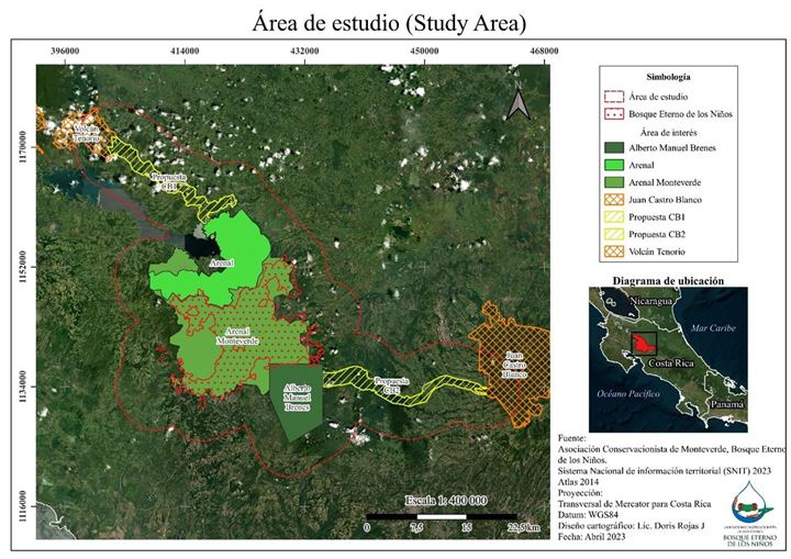
Fig. 1. Area of study showing the current protected areas in the region plus the two biological corridors proposed by Moran et al. 2019. The red line outlines the area designated as our study region.
Description
Since the last progress report, we have now completed most of the preliminary maps. These include eight distinct maps: basic study area, protected areas, biological corridors, political boundaries of study area, elevation, slope angle, watersheds, land-use, and Holdridge life zones (see figs at end of this document). With the exception of the watershed figure, the data are complete. We are still working on calculating watershed ecosystem services because data on hydroelectric generation has been difficult to obtain. No public database exists for electricity production in Costa Rica, so we are in the process of contacting individual companies and it does appear that we will be able to gather the needed information. With the completion of this final map, we will then be able to calculate our priority land protection locations for the future.
Now that we have (nearly) all of our maps completed, we have developed an algorithm to calculate our priority lands. This calculation assigns values to each location within our study area to create a ranking (0-12) of land for conservation. Variables extracted from our maps for each location (6 total) are land-use, slope angle, proportion of life zone protected, biodiversity of life zone, presence of priority corridor, and hydroelectric power generation. Our current model has each variable weighted equally, although we will create additional models that more heavily weight our most important conservation variables (biodiversity, connectivity, and natural forest cover). From these models we will then create our final map(s) that show where we should focus conservation efforts in the medium-long term.
Jan. 2024 Update - Since the last progress report in November, we have completed our final map, for the study area. We are now working on the manuscript of this study with recommendations for where conservation efforts should be focused in the medium- to long term.
Next steps: We will organize meetings with other conservation partners, including SINAC, regional private conservation organizations, ecotourism operators, and national and international conservation NGOs, to discuss findings and next steps. $2,524 in remaining funds from the grant have been reserved for publication costs and additional map edits.
B. Camera trap research. With funds provided by the grant and in consultation with the Alex C. Walker Foundation, the Monteverde Conservation League purchased 18 new wildlife cameras to help in the continued work to monitor mammals within the Children’s Eternal Rainforest. With the new cameras, we have been able to augment current camera placement at existing locations, and add two additional locations near the recently purchased Máximo Ramírez property. The cameras are now fully installed at our long-term monitoring sites and are collecting data daily. We recently had an intern who curated all the photos from 2021-22, so we now have baseline values for mammal and ground bird diversity that we will use for our long-term trend line analysis in subsequent years. The next step in this monitoring program is to deploy cameras to remote (internal) areas of the BEN, starting in February 2024, in order to gather data from this vast and largely undocumented area.
C. Summary. We continue to be pleased and excited about the results of this project. Although the timeline has been extended, we are confident that this project will provide valuable information for future land purchase and conservation decisions. It has already produced maps and visuals that will be useful for research, education, and outreach. The results from the camera traps are not only exciting, but provide important baseline data for future monitoring and research.

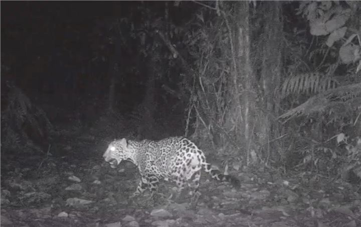
Jaguar, a keystone species, photographed by camera trap Children's Eternal Rainforest.
Purpose
The BEN creates a market-based economy centered on ecotourism and education by attracting numerous tourists and student groups. The BEN is the centerpiece of a protected area connecting Monteverde and La Fortuna, locations that attract hundreds of thousands of visitors each year. Tourism has important direct and indirect economic effects on communities and is a great example of how biodiversity protection improves people's lives. With almost every family in some way associated with the ecotourism economy (some indirect, but many direct), support for conservation is strong. Since the BEN also protects soil, regulates water supply, and improves air quality, the ecosystem services extend well beyond its physical boundaries, providing benefits to hydroelectric generation, agriculture, and general quality of life. Improving biodiversity protection and ecosystem services for the future will help ensure a strong conservation-based economy and continue to improve the communities of the region.
Scope
This project will identify areas with high conservation and ecosystem services values that surround the protected lands in the Monteverde-Arenal region of Costa Rica, a biodiversity hotspot and a world-renowned ecotourism destination. Protected lands here currently exist as an island of high quality habitat. This isolation threatens long-term survival of species and may damage the economically important ecotourism sector. These lands are also critical to Costa Rica’s electricity generation system, water supply, and agriculture production. Using Geographical Information Systems (GIS) analysis, we will identify the best lands for future protection that maximize biodiversity protection, ecosystem services, and benefits to the ecotourism economy. Once this analysis is completed, we will approach conservation organizations, donors, and interested parties to implement an effective long-term land use plan. This analysis could be a model for other ecologically important regions of the world.
Amount Approved$20,000.00
on 11/10/2022
(Check sent: 11/18/2022)